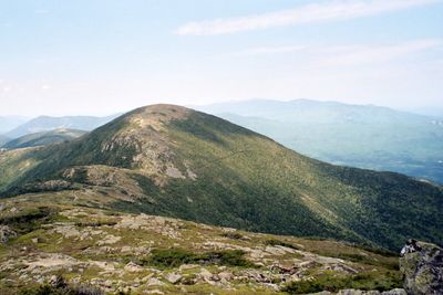
Mount Eisenhower rises to 4,763 feet at the southern end of the Presidential Range, sitting between Mount Pierce to the south and Mount Franklin to the north. Known as Mount Pleasant until 1969, when the New Hampshire Legislature renamed it in honor of President Dwight D. Eisenhower, the mountain stands out for its broad, rounded summit well above treeline. The four-plus-acre alpine zone at the top gives unobstructed views in every direction: Mount Washington dominates the northern skyline, Monroe and the Southern Presidential ridgeline stretch nearby, and the Dry River Wilderness opens to the south and east.
The most direct approach is via the Edmands Path, a 3.3-mile route from a trailhead on Mount Clinton Road that climbs roughly 2,700 feet through mixed forest before breaking into open terrain near the ridge. A longer option follows the Crawford Path from Crawford Notch, which carries the Appalachian Trail over the summit. Both routes expose hikers to open, rocky terrain in the upper half, where footing requires care. Many hikers extend the trip to include nearby Mount Pierce via the Crawford Connector.
Summer afternoons bring frequent thunderstorms to the exposed summit, and high winds are possible any time of year. The open summit makes an early morning start worthwhile, particularly on weekends when the Edmands Path trailhead fills quickly. Snow lingers on the upper slopes into May.