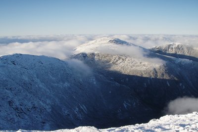
Mount Jefferson, at 5,712 feet, is the third-highest peak in New Hampshire and ranks among the tallest summits in the Northeast. It sits at the center of the Presidential Range, flanked by Mount Adams to the northeast and Mount Clay to the south, with three glacial cirques falling from its flanks: Jefferson Ravine, Castle Ravine, and the Great Gulf Wilderness. The summit is a broad, rocky plateau well above treeline with sweeping views along the full Presidential ridge and down into those ravines.
Two main ridges give access. The Caps Ridge Trail starts from Jefferson Notch at 3,008 feet, the highest trailhead on any public road in New Hampshire, and climbs 2.5 miles and roughly 2,700 feet to the summit. Named for three prominent rock outcrops near the top, the route involves short scrambles as krummholz gives way to open ridge. It is the shortest approach to any major Presidential summit. The Castle Trail, from US Route 2 to the north, follows the narrow, serrated crest of Castle Ridge for 4.4 miles and 4,200 feet of gain, with significant exposure throughout. Jefferson is also a natural stop on the Presidential Traverse via the Gulfside Trail.
Jefferson Notch Road is unplowed in winter, eliminating the Caps Ridge option; winter routes via Castle Ridge or Edmands Col are long and fully exposed. Above treeline at any season, conditions change rapidly, and summer afternoons bring lightning risk across the open ridge.