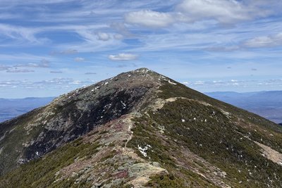
At 5,242 ft, Mount Lafayette is the highest peak in New Hampshire outside the Presidential Range and the northern anchor of the Franconia Range. Originally called Great Haystack Mountain, it was renamed in 1824 when Franconia residents formally dedicated the summit to General Lafayette on the anniversary of the British surrender at Yorktown, during his farewell tour of America. The upper mountain holds the third-largest connected area of alpine tundra east of the Rockies, a fragile zone of windswept heath, mosses, and krummholz stretching south along the ridge through Mount Lincoln to Little Haystack.
The classic route is the Franconia Ridge Loop, 8.9 miles with 3,900 ft of gain. Most parties ascend the Old Bridle Path to AMC's Greenleaf Hut at 4,200 ft, continue up the Greenleaf Trail to the summit, then traverse open tundra south over Lincoln and Little Haystack before descending Falling Waters Trail past Cloudland Falls. The ridge remains fully above treeline for over two miles, with views east into the Pemigewasset Wilderness, west to the Kinsman Range, and northeast to Mount Washington on clear days. The Skookumchuck Trail from Route 3 offers a quieter approach via North Lafayette with far less foot traffic.
The ridge's full exposure demands respect: summer afternoon thunderstorms build fast, ice persists on upper slopes into April, and winds are often fierce year-round. Late September through mid-October brings the year's clearest visibility, with hardwood foliage blazing in the valleys below.
 David Andre
Reference


Weather


Conditions


Trails
 Mount Lafayette and Franconia Ridge Trail Loop
- Old Bridle Path
- Greenleaf Trail
- Mt. Lafayette, Little Haystack, Mt. Liberty, and Mt. Flume Loop
- Mount Lafayette, North Lincoln, and Little Haystack Loop
- Liberty and Franconia Ridge Loop
- Skookumchuck Trail
- Mt. Flume, Liberty, Little Haystack, Lincoln, Lafayette, and Garfield