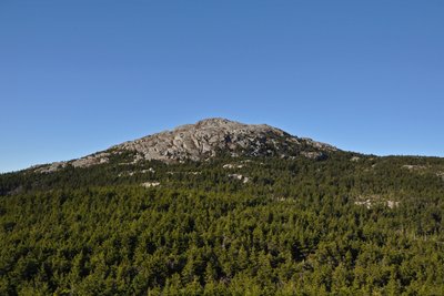
Mount Monadnock rises to 3,165 feet above Cheshire County's farmland, standing nearly 1,000 feet higher than any other peak within 30 miles. Its bare, rocky summit traces to fires set by early settlers between 1800 and 1820, first to clear pasture, then to drive out wolves. The blazes raged for weeks, destroying topsoil above 2,000 feet and leaving an artificial treeline well below the climatic norm. The exposed schist and quartzite gave geologists the word "monadnock" for isolated resistant peaks. Emerson and Thoreau each made the climb and wrote extensively about it; a bog near the summit still bears Thoreau's name.
Monadnock State Park maintains over 36 miles of trails from multiple trailheads. The White Dot Trail (2.2 miles from park headquarters) is the shortest and steepest route, climbing slabs and rocky staircases to the open summit. The White Arrow Trail (2.3 miles via the Old Toll Road) is the gentlest ascent. For the fullest ridge experience, the Pumpelly Trail (4.4 miles from the northeast) stays open and panoramic for much of its length.
The summit delivers 360-degree views reaching the White Mountains, Mount Washington, and the Boston skyline on clear days. Alpine plants including sheep laurel, mountain cranberry, and cotton grass cling to shallow soil pockets on the exposed rock. No water is available above 2,000 feet; summer thunderstorms develop quickly, and snow and ice can persist on busy trails well into May.