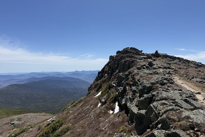
Mount Monroe rises to 5,369 feet in the Presidential Range, sitting just southwest of Mount Washington and directly above the two small tarns known as the Lakes of the Clouds. Entirely above treeline, the summit occupies a sub-arctic alpine zone where conditions can shift rapidly in any season. From the top, views span the full Presidential ridge to Mount Washington, north to Jefferson and Madison, south through the Dry River Wilderness, and west into Vermont.
The most traveled route follows the Ammonoosuc Ravine Trail from the Base Road trailhead, a 3.1-mile, 2,500-foot climb that passes Gem Pool and a pair of waterfalls before arriving at the Lakes of the Clouds Hut. From there, the Crawford Path, the oldest continuously maintained footpath in the country (built in 1819), continues to the Monroe Loop, a short 0.5-mile spur gaining only 360 feet to the summit. The flat plateau just south of the high point, Monroe Lawn, shelters Robbins Cinquefoil, an endangered plant found almost nowhere else in the world; hikers should stay on trail through this fragile area.
Late June and July bring peak wildflower blooms across the alpine lawn. The fully exposed ridge catches weather quickly from the west, so carrying layers and starting early are sensible precautions in any season.
 David Andre


