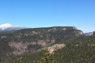
Stairs Mountain takes its name from the "Giant Stairs," a dramatic series of ledge steps that form the mountain's south face, visible from surrounding peaks like Mount Crawford and easily recognized as a staircase in the sky. At 3,469 feet, the mountain sits deep in the Presidential Range-Dry River Wilderness southeast of Crawford Notch, a remote corner of the White Mountain National Forest.
The most common approach is via the Davis Path from Route 302 in Bartlett, a roughly 9 to 10 mile round trip to Stairs alone, with an optional extension to neighboring Mount Crawford and Mount Resolution. The first two miles gain 2,000 feet steeply; beyond the Crawford junction, the grade eases considerably before a short spur leads to the summit. An alternate approach follows the Rocky Branch Trail and Stairs Col Trail from the east, a longer and more isolated route through the Rocky Branch Valley.
The summit ledge sits at the top of the cliff steps with views west toward Mount Crawford and Mount Resolution, east down the Rocky Branch Valley, and south into remote wilderness. A primitive tentsite sits just below the overlook, though it is a dry camp requiring hikers to carry their own water. The exposed cliffs are often windy, and rock slabs on Davis Path become treacherous in wet conditions.
 David Andre


