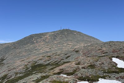
The highest peak in New England at 6,288 feet, Mount Washington anchors the Presidential Range and carries a worldwide reputation for severe, rapidly changing weather. The summit plateau is a broad talus field shared by the Mount Washington Observatory, a cafeteria, and a museum; the Observatory has maintained continuous weather records since 1932 and recorded a surface wind of 231 mph in April 1934, a world record that stood for over six decades. On clear days the view extends across five states and into Canada, but clear days are not guaranteed; the summit averages only about 60 per year.
Most hikers approach from Pinkham Notch to the east. The Tuckerman Ravine Trail (8.4 miles round-trip, 4,250 ft gain) passes Crystal Cascade and climbs through the glacial cirque celebrated for spring backcountry skiing before gaining the rocky upper cone. A fine loop pairs the descent with the Lion Head Trail, which scrambles Class 3 ledges above the ravine's north rim. From the west, the Ammonoosuc Ravine Trail passes Lakes of the Clouds Hut before joining the Crawford Path, the oldest continuously maintained hiking trail in the United States and part of the Appalachian Trail.
All routes above treeline cross exposed talus with no shade or shelter. Hypothermia is a real risk in every month of the year; always check the Higher Summits Forecast before heading up.
 David Andre
Reference


Conditions


Trails
 Mount Washington via Ammonoosuc Ravine Trail
- Tuckerman Ravine and Lion Head Trail
- Mount Washington and Monroe via Ammonoosuc Ravine Trail
- Tuckerman Ravine Trail
- Ammonoosuc Ravine to Crawford Path
- Tuckerman Ravine, Davis Path, and Boott Spur Trail
- Tuckermans Ravine and Boott Spur Trail
- Alpine Garden, Lion Head, and Tuckerman Ravine Trail