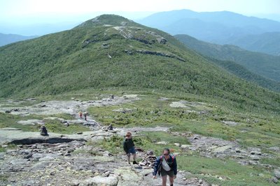
Iroquois Peak is the eighth-highest summit in New York at 4,840 feet and the southwesternmost of the MacIntyre Range's High Peaks, set in the heart of the High Peaks Wilderness. Its name has a tangled history: surveyor Verplanck Colvin used three different names for it on successive maps, and even the Marshall brothers initially assigned the "Iroquois" name to nearby Mount Marshall before ultimately settling the question in the 1920s. The peak has no officially maintained trail, which means reaching it requires passing over Algonquin Peak first.
Most hikers approach via the Algonquin Trail from the Adirondack Loj, following MacIntyre Brook past MacIntyre Falls before climbing steeply to Algonquin's open summit. From there, a well-worn cairned herd path leads southwest, dropping briefly to Boundary Peak before a final steep push to the Iroquois summit, roughly 1.1 miles from Algonquin. The full round trip runs about 9.4 miles with around 3,250 feet of gain.
The summit is completely open and exposed, delivering sweeping views of the High Peaks, the Algonquin-Wright massif, and Keene Valley far below. That exposure also means conditions can deteriorate quickly: afternoon thunderstorms are common in summer, and lingering snow can make the herd path icy into May. Hikers combining Iroquois with Algonquin and Wright in a single day get three of the 46ers at once, though the mileage and sustained climbing demand a solid fitness base.
Reference


Weather


Conditions

Trails
 Algonquin, Iroquois and Wright Peaks via Algonquin Trail
- Avalanche Pass
- Algonquin and Iroquois via Algonquin Trail
- Wright Peak, Algonquin Peak, Iroquois Peak and Avalanche Lake Loop
- Wright, Algonquin, Iroquois, Gray, Skylight, Marcy Loop
- Wright, Algonquin, Iroquois, Mount Colden, and Mount Marcy Trail Loop